The Ohio to Erie Trail is a primarily off-street recreational trail that, when completed, will span the state of Ohio from Cincinnati to Cleveland. For the most part, it follows land formerly occupied by railroads and canals. The trail connects four of Ohio’s metropolitan cities, a dozen large towns and numerous small villages with connected, easily accessible, paved trails.
The trails are used by bicyclists, hikers, skaters, families with strollers, bird watchers, and others wishing to enjoy them. As of 2020, the Ohio to Erie Trail consists of approximately 280 miles of paved trails separated from streets. Ultimately, the trail will be about 320 miles long, once all segments are completed.
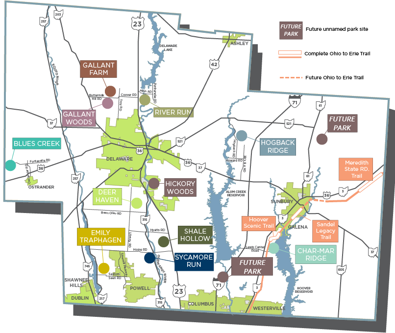
The OTET is owned and managed by numerous communities/agencies, all working together to form a connected trail system. Preservation Parks manages three segments of the Ohio to Erie Trail, all described below.
Location: 8405 Plumb Road, Galena, OH 43021
Trail Length: 0.6 miles
Hours of Operation: Trail open at all times to allow for commuting
Trail Information: The Hoover Scenic Trail extends from Plumb Road to Weise Road, south of the village of Galena, crossing Old 3C Highway via a bicycle and pedestrian bridge. It runs along the shore of the Hoover Reservoir and through the Hoover Nature Preserve (owned by the City of Columbus.)
Wildlife: A number of native wildlife have been spotted along the trail, including white-tailed deer, eastern cottontail rabbit, eastern chipmunk, gray squirrel, woodchuck, American beaver, muskrat, coyote, red fox, raccoon and striped skunk.
Many native and migratory bird species have also been spotted along the trail, including prothonotary warblers, bald eagle, osprey, cliff swallows, American avocet and marbled godwit.
Location: 5769 N County Line Road, Centerburg, OH 43011
Trail Length: 5.3 miles
Hours of Operation: Trail open at all times to allow for commuting
Trail Information: The Meredith State Road Trail is a segment of the Ohio to Erie Trail that extends roughly from the outside of Sunbury, northeast to the Delaware-Licking County line. The segment is paved and open for use, but is not yet connected to other segments to the Ohio to Erie Trail.
Parking is unavailable and users must walk or bicycle in. A parking lot at the trailhead at the Licking County line is currently under construction.
Location: 168 S Vernon St., Sunbury, OH 43074
Trail Length: 0.6 miles
Hours of Operation: Trail open at all times to allow for commuting
Trail Information: The Sandel Legacy Trail is a portion of a rail trail connecting Galena and Sunbury. Parking and a picnic area are located at the trail entrance in Sunbury. Shops and restaurants in Galena and Sunbury’s historic town squares are accessible from the trail.
As you walk the trail, watch for catbirds, groundhogs and other wildlife. The trail was donated to Preservation Parks by Walter and Kathy Sandel in 1990, and funding for the trail conversion was provided by a Nature Works Grant.
The trailhouse was purchased in 2002 and currently houses the Delaware County Model Railroaders group.
For more information on the Ohio to Erie trail and trails around Central Ohio, please visit the websites below.
Delaware County Friends of the Trail
Ohio to Erie Trail
Central Ohio Greenways
MISSION: To protect and conserve the natural and historic features of Delaware County and to inspire outdoor exploration and learning.
VISION: To inspire the care of nature and community for a sustainable future.